Qué ofrece Heritalise
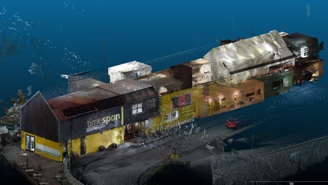
The 2nd general assembly of the Heritalise project marked an important step in the practical application of digital technologies for cultural heritage. Hosted at the TimeSpan Museum in Helmsdale- Scotland, the Assembly went beyond coordination and discussion, becoming a dynamic setting for hands-on experimentation and innovation. During this event, a comprehensive 3D survey campaign was successfully carried out to support the digitalisation of the museum, combining state-of-the-art SLAM systems and drone-based photogrammetry.
Aplicaciones de Heritalise
As the other case study of the project the TimeSpan Museum provided an ideal environment for showcasing these technologies. With its distinctive architecture, diverse interior spaces, and strong connection to the surrounding landscape, the museum served as a living laboratory for testing efficient, non-invasive, and scalable digital documentation methods. The survey activities carried out highlight how advanced digital tools can be effectively deployed in real heritage contexts, delivering tangible results while fostering collaboration and shared learning among project partners.
The primary goal of the 3D survey activities was to create a detailed digital representation of the Museum, supporting its long-term documentation and digital transformation. This objective aligns closely with the broader vision of the Heritalise project: to empower cultural heritage institutions through innovation, sustainability, and knowledge exchange. Partners were able to observe the technologies in action, discuss workflows, and reflect on how similar approaches could be transferred to other heritage sites across Europe and beyond.
A key component of the digitalisation campaign was the use of Simultaneous Localisation and Mapping (SLAM) technology to document the interior and exterior spaces of the TimeSpan Museum. SLAM systems allow operators to capture 3D data while moving through an environment, simultaneously recording geometry and tracking their position. This makes them particularly well suited to museums and historic buildings, where speed, flexibility, and minimal impact are essential.
Cómo contribuye nuestro proyecto a los Objetivos de Desarrollo Sostenible
-AS
-asasasa
-SAFSAD
-FDGDSF
-ASDQDASF SAFDF SDARFT
During the GA, handheld SLAM devices were used to survey exhibition rooms, corridors, staircases, and service areas. The mobility of the system enabled the operator to move naturally through the museum, capturing continuous spatial data without the need for complex setup procedures. This approach significantly reduced survey time while maintaining a high level of geometric detail.
The benefits of SLAM were immediately evident. Complex interior layouts, multi-level spaces, and areas with limited accessibility could be documented seamlessly. The resulting point clouds accurately captured walls, ceilings, floors, and architectural features, providing a robust foundation for three-dimensional modelling and analysis. The non-contact nature of the technology ensured that the survey process respected conservation requirements, avoiding any physical interaction with historic fabric or museum displays. SLAM acquisitions were georeferenced using ad hoc-materialized markers, whose positions were determined by means of GNSS-NRTK (Global Navigation Satellite Systems – Network Real Time Kinematik) techniques